Old train tracks

BaymaxFan78

Fort Wilderness Enthusiast
Joined
Mar 10, 2019
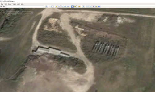
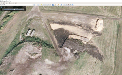
I found a video from about 8 years ago. In the video they were walking down the old tracks behind the 700 loop and found a separate path that went left to an area that is today directly south of the horse barn. It was a wide open field with 2 abandoned life jacket boxes. Has anyone been to that area, what is the purpose of it, and is it still accessible? It was pretty neat
 
I found a video from about 8 years ago. In the video they were walking down the old tracks behind the 700 loop and found a separate path that went left to an area that is today directly south of the horse barn. It was a wide open field with 2 abandoned life jacket boxes. Has anyone been to that area, what is the purpose of it, and is it still accessible? It was pretty neat

Yes.

The old FW Railroad track, as initially built, ran between 700 and 800 loops on its way down towards Bay Lake. That area is now a dog walk area but from the main road Fort Wilderness Trail you can look off to the left and still see the remains of the wooden rail ties.

If you follow the ties back behind 700, you come to a wye. You can see the grade (nice and level mostly) of the ground with a left fork and right fork. The left fork is the one you're referring to which goes out and around with an open (low) field (which looks back toward the group camping area Creekside Meadow).

I followed that left fork (fought my way through the brush and trees) and saw the boxes but didn't know and didn't care since I was following the railroad grade. I seem to recall last time I was in that area there was some sort of sign like ("Turn Around").

The one thing I noticed about that field is that it is rather low compared to the campsite loops and nearby roads. I don't know if it's considered "wetlands" or not. But I do recall leaving the grade and going down a slope that was several (4-8 ft) lower to the field than the grade.

There is open space behind 800 loop that is easy to :rolleyes: wander around in and not encounter a sign. :rolleyes1

Bama Ed

PS - at the wye I spoke of, the right fork is the original railroad bed that followed behind 700 loop on its way to the stop at the entrance to 400 loop after crossing FW Trail road. Later when River Country was built, the left wye branch was added to move the stop from 400 back across FW Trail to across the road from the current Settlement Bus Depot area as a means of carrying River Country guests to and from the front parking lot (I have tramped my way around both forks). RC is the only reference I can think of as to why anything in that area would be life jacket related. Or else you have to drag those things up from the FW dock I would think.
Thanks for the info. I've been down the tracks before (last May in fact) but I don't remember it going far, I thought there was some sort of barrier now but maybe it was just overgrown. I'm definitely going to explore some more next time I go.

I have been down the area behind 800 all the way to creekside meadow. It's a very nice walk.

Perhaps there is now and that's what the "Turn Around" meant in my head. :crazy:
 
@bama_ed
So I'm not as knowledgeable on the geography as you all, but where was the old life jacket box in relation to the field you're talking about? You said "The one thing I noticed about that field is that it is rather low compared to the campsite loops and nearby roads. I don't know if it's considered "wetlands" or not. But I do recall leaving the grade and going down a slope that was several (4-8 ft) lower to the field than the grade." Is it possible it was a dry lake? Not really adding anything to the conversation but just curious.
 
Don/@Stratman50th,

I put together some slides and in the process realized something important.

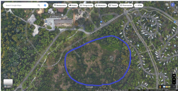
First when you look at the area behind loop 700 in Google Maps, it doesn't tell you but the image shown (at least for me) turns out to be from Nov 2018 (no new TCD barn across the road). The "field" in question is circled in blue in this pic.

2 Base Area Behind 700 and 800 Loops Field in Question.png

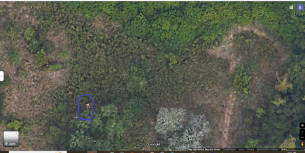
I have not been in those woods any more recently. The box(es) in question are in this zoomed in pic which shows the upper right inside corner of the blue circle more closely. They are also circled blue.

5 Base Area Behind 700 and 800 Loops Closeup.PNG

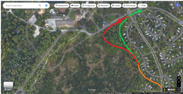
The railroad bed and the dog area between 700 and 800 are outlined in this pic.

3 Base Area Behind 700 and 800 Loops RR loops.png

The orange line is the dog walk area single line. As I said, originally the orange line led to the green line with the original "Settlement Train Depot" as the green dot just before loop 400 entrance. When River Country was built, Disney built the red line, abandoned the green line, and moved the "Settlement Train Depot" to the left where I put the red dot. Closer to drop RC guests off to RC.

I walked the red line and saw the box(es) off to the left (above) which were down a slope about 3-5 vertical feet to the natural elevation of that field (train tracks were generally level all throughout the Fort - generally so the red line probably had fill brought in to raise it up to the orange/green elevation when it was constructed).

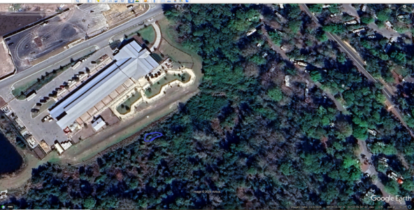
But now with the new TCD area across the road, who KNOWS what's left in that field. Here is a grab from Google Earth with the approximate location of the box(es) circled in blue. This (Feb 2024) is the most current picture currently in Google Earth of the area.

4 700 & 800 Google Earth Feb24.PNG

The box(es) may be gone.

The new TCD barn appears to have taken a chunk out out of the red line branch of the railroad as well.

What's REALLY interesting is to take that circled field in the first pic and find the matching photo in Google Earth from Nov 2018 and then click "backwards" in time. That "field" has been a forest, blow down area, thick with vegetation and trees, and somewhat barren.

I'll have to check this area out again when I'm at the Fort in November. Honestly, I did not think that the TCD buildout would have infringed that far into the "field" to where the box location was/is.

I'm glad @BaymaxFan78 brought this subject up. They may be there sooner and could give us the new readout.

Bama Ed

PS - and that "field" from 2018 looks in the 2024 pic like it's filled in, bushed out, and grown up a lot, doesn't it?

PPS - clicking backwards in time with Google Earth is fun - you can learn a lot. For instance, I know where 10 of the 12 submarines from 20,000 Leagues Under the Sea (classic old Fantasyland ride from MK) are kept (the other two are stored somewhere prolly in an Imagineering warehouse and pulled out occasionally for events like the Disney Marathon [I ran past one on a flat bed truck when I did the 2017 Full Marathon]).
 
Last edited:
Don/@Stratman50th,

I put together some slides and in the process realized something important.

First when you look at the area behind loop 700 in Google Maps, it doesn't tell you but the image shown (at least for me) turns out to be from Nov 2018 (no new TCD barn across the road). The "field" in question is circled in blue in this pic.

View attachment 859630

I have not been in those woods any more recently. The box(es) in question are in this zoomed in pic which shows the upper right inside corner of the blue circle more closely. They are also circled blue.

View attachment 859631

The railroad bed and the dog area between 700 and 800 are outlined in this pic.

View attachment 859632

The orange line is the dog walk area single line. As I said, originally the orange line led to the green line with the original "Settlement Train Depot" as the green dot just before loop 400 entrance. When River Country was built, Disney built the red line, abandoned the green line, and moved the "Settlement Train Depot" to the left where I put the red dot. Closer to drop RC guests off to RC.

I walked the red line and saw the box(es) off to the left (above) which were down a slope about 3-5 vertical feet to the natural elevation of that field (train tracks were generally level all throughout the Fort - generally so the red line probably had fill brought in to raise it up to the orange/green elevation when it was constructed).

But now with the new TCD area across the road, who KNOWS what's left in that field. Here is a grab from Google Earth with the approximate location of the box(es) circled in blue. This (Feb 2024) is the most current picture currently in Google Earth of the area.

View attachment 859633

The box(es) may be gone.

The new TCD barn appears to have taken a chunk out out of the red line branch of the railroad as well.

What's REALLY interesting is to take that circled field in the first pic and find the matching photo in Google Earth from Nov 2018 and then click "backwards" in time. That "field" has been a forest, blow down area, thick with vegetation and trees, and somewhat barren.

I'll have to check this area out again when I'm at the Fort in November. Honestly, I did not think that the TCD buildout would have infringed that far into the "field" to where the box location was/is.

I'm glad @BaymaxFan78 brought this subject up. They may be there sooner and could give us the new readout.

Bama Ed

PS - and that "field" from 2018 looks in the 2024 pic like it's filled in, bushed out, and grown up a lot, doesn't it?

PPS - clicking backwards in time with Google Earth is fun - you can learn a lot. For instance, I know where 10 of the 12 fiberglass submarines from 20,000 Leagues Under the Sea (classic old Fantasyland ride from MK) are kept (the other two are stored somewhere prolly in an Imagineering warehouse and pulled out occasionally for events like the Disney Marathon [I ran past one on a flat bed truck when I did the 2017 Full Marathon]).
I will be there I'm July! Definitely doing some exploring.

It is weird how different it looks in 2024. However, aerials can be deceiving and the 3d view shows much more detail on where the open areas are. The 3d hasn't been updated since 2018 but it gives you an idea.

This is the video I'm referring to. (Shoutout to Roadtrippin, love their videos and they are very nice people!)

It's such a random thing but this intrigues me so much. A random somewhat open area connected to the campground, and the abandoned life jacket boxes, it's just kinda weird. I call it a field but I don't know what the actual term is. Large overgrown area without trees? Lol.

The new barn has certainly taken over most of the area but I think there is a portion, specifically where the boxes were (and most of the area shown in the video) is still there. It may be way overgrown now and have larger trees, but it's there.

Things like this make me wish drones were allowed at WDW.

Spill the tea on the submarines! I always thought they were buried at the landfill area.

Also. Analyzing every inch of WDW on Google Earth using the time travel feature is my favorite pass time. Especially when they update it with newer imagery.
 
DH and I have trekked through some of that wilderness many years ago when it was overgrown. Never saw a box.

Please dish on the submarines. Anything 20k related he collects including pictures.
 
DH and I have trekked through some of that wilderness many years ago when it was overgrown. Never saw a box.

Please dish on the submarines. Anything 20k related he collects including pictures.

Well, as @BaymaxFan78 said, they're buried in the landfill.

There were 12 submarines. As I said earlier, 2 were preserved and saved. The other 10 are sleeping in the ground.

From Google Earth, here is a pic of the 10, side by side in pairs, in March 2005 (they had showed up there in 2004 but this is one of the better GE pics).

1715898076920.png

In the next year, they were buried/covered over.

1715898165539.png

Sad ending to a fun ride.

Getting us back on track, it was sad when the Fort Wilderness Railroad stopped running. Now all we're left with is some remaining wooden ties, ballast used between the ties in spots, the grade, a few odds/ends in the ground, and memories.

Bama Ed
 
Well, as @BaymaxFan78 said, they're buried in the landfill.

There were 12 submarines. As I said earlier, 2 were preserved and saved. The other 10 are sleeping in the ground.

From Google Earth, here is a pic of the 10, side by side in pairs, in March 2005 (they had showed up there in 2004 but this is one of the better GE pics).

View attachment 860531

In the next year, they were buried/covered over.

View attachment 860532

Sad ending to a fun ride.

Getting us back on track, it was sad when the Fort Wilderness Railroad stopped running. Now all we're left with is some remaining wooden ties, ballast used between the ties in spots, the grade, a few odds/ends in the ground, and memories.

Bama Ed
Thank you @bama_ed for the pics. He'll love to see them. I believe the one submarine submerged at Castaway Cay for snorkeling could be one of those? We've been there ourselves.

Back on topic, each year we go exploring looking for any remnants of the tracks, ties, ballast. It's slowly returning to the earth. We keep trekking in the brush looking. Both of us never saw the railroad because our families stayed offsite and only visited the parks. By the time we were old enough to come to River Country by ourselves, the train was gone. Sometimes we wish we were born earlier. We remember vicariously through others' memories, videos and pictures.
 

GET A DISNEY VACATION QUOTE

Dreams Unlimited Travel is committed to providing you with the very best vacation planning experience possible. Our Vacation Planners are experts and will share their honest advice to help you have a magical vacation.

Let us help you with your next Disney Vacation!


Latest posts


facebook twitter
Top